I. Objectives
- Make a geologic map of the Cambrian/Precambrian nonconformity
on ranch property south of Streeter.
- Write concise unit descriptions of each of the map units -
Riley Fm., Hickory Sandstone and Calcite/Dolomite Marbles of the Packsaddle Schist.
- Make a geologic map of folded Precambrian marbles.
II. When
- April 28-29 (Drs. Helper & Marrett; this is an overnight trip - all sections go
the same weekend)
We depart Saturday at 7:00 AM from the
east basement door and will be back on campus by about 8:00 PM Sunday.
III. Bring
- Two lunches
- Camping gear (can be
rented from
UT RecSports)
- sleeping bag
- sleeping pad
- + tent
- Compass, GPS, hand lens, hammer
- Clipboard, field book
- Ink pens (2), colored pencils, eraser, protractor, mech. pencil, white out.
Breakfast and dinner will be provided. Please email
Dr. Helper if you are a vegetarian.
|
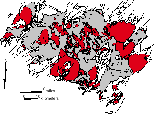
Precambrian granites (red) and host gneiss/ schist units (gray), Llano
uplift.
IV. Background Material
 Map
symbols for this project
Map
symbols for this project
|